county list
![]()
|
Turn smartphone to horizontal
view. SELECTED SITES IN COUNTY DUBLIN Place-names in italics refer to listed entries. Convert Irish Grid references to Latitude/Longitude |
|
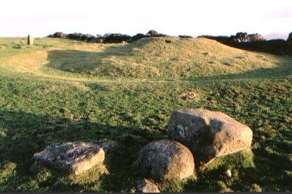
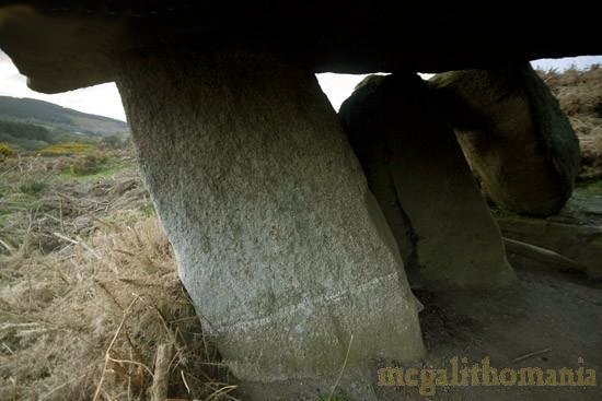
On the slope of Two-Rock Mountain, in a conifer plantation above a golf-course to the W of a by-road between the N.43 and the R.41 is a fine, unusually large and beautifully-situated Wedge-tomb once commanding a fine view to the SW. Some of its kerbstones are massive, and though ruinous, the rectangular, double-walled gallery, divided into portico, main chamber and closed E chamber (as at Labbacallee in county Cork) are well-defined. ~ 500 metres N by E, to the right of a track in the woods (O 186 217) is a fallen standing-stone which may be the sole survivor of a stone circle. ~ About 800 metres SE, on Newtown Hill on the other side of the by-road (O 193 212) is a fine ring-barrow with a standing-stone 1.4 metres tall just outside it, which appears to be aligned with sunrise at the summer solstice
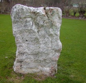
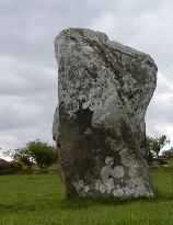
~ 1.2 km SSE at Glencullen (O 192 203), situated over a low wall E of a by-road near a tee on a small golf-course (use nearest gate for access, not the golf-course) is a superb quartz Standing-stone about 1.5 metres square (compare Cregg in county Derry and Ballynoe in county Down). click
for a high-resolution photo ~ A little
over 4 km NW, in thick woodland about 100 metres above a car-park
on the Wicklow Way at Kilmashogue (O 152 245)
is a ruined Wedge-tomb with denuded cairn in which several kists
were inserted at a later date. The roofless gallery is triple-walled,
and the very high sill-stone between the antechamber and main
chamber is another unusual feature.
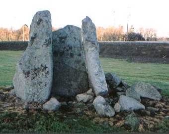
~ About 5 km NW, East of St Columba's College, in Taylor's Grange (O 158 255), in the middle of a grassy area on a turn-of-the-century housing estate which now occupies what was once Glynsouthwell Demesne, are the imposing remains of a portal-tomb known as "The Brehon's Chair": two orthostats and a door-stone 3 metres high. They are in the centre of a circular depression about 30 metres across.
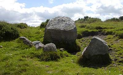
~ 6 km WNW in Rockbrook (O 138 249) is a pair of slender standing-stones about 1.6 metres high in a field to the N of a by-road leading on to the R.116 - marked as only one stone on the map. These are in line with another similar (leaning) stone in the same townland on the other side of the road behind the wall in a paddock (O 141 247). In the hedgerow to the N of the road are six other similar stones which suggest that there might here have been an important alignment. ~ 7 km W by S, in Glassamucky Brakes (O 115 209) are the remains of county Dublin's only surviving stone circle, about 60 metres up the slope from a by-road, on a small shelf that looks due west across the valley. On the west side of the circle 7 stones still stand (the highest being 90 cms), including an axial stone which is leaning out of the circle. ~ 6.5 km WSW, on the Dublin-Wicklow border (O 129 214), about 120 metres up the hill from the R.115 in Glassamucky Mountain is a massive boulder in which there is a very large, flat bottomed bullaun over 35 cms in diameter. Two other bullauns of equal size have been eroded. This bullaun is at least as old as the Bronze Age, and SE from it can be seen the significant top of the quartz cone of Great Sugar Loaf Mountain. Not far away is a smaller boulder with the narrow, elongated cup-marks typical of North Wicklow and South Dublin along its upper edge, aligned with the winter-solstice sunrise in a notch to the S of the Great Sugar Loaf. ~ 7 km WSW in Cunard (O 117 199, unmarked on Sheet 56), down the hillside from a by-road, are the charming remains of a portal-tomb attractively situated on a little hump around which a peaty brown stream gurgles. Though it may have originally been two metres high, it is now only 1.6 metres, since the portal-stones have vanished. The capstone, some 2.2 metres long, rests on the sidestones of the small chamber. ~ In the same townland, at O 119 199 on a fairly steep slope, is an alignment of three pointed stones around 1.2 metres high with unraised stones all around. At the SW end is a circular platform which may be artificial. ~5.5 km ENE is Brenanstown
(Glendruid) Portal-tomb. Ballymana:
Megalithic kerb or Stone circle 30 metres W of the artificial Mound on Knockanvinidee marked on the map is an oval circle of stones surrounding a low mound which was (according to the Ordnance Survey papers for county Dublin) a cairn containing a tomb. On the NE side is a spectacular stone with a quartzite face, which would shine brilliantly in the first rays of daybreak around the summer solstice, when the sun would rise over the sacred peninsula of Howth, towards which so many Dublin monuments are aligned. (This is not unique: the door-stone of the passage-tomb at Bretteville near Cherbourg in Normandy has a similar 'veneer' of quartzite.) On the SW side is a pointed stone emphasising the axis, while at the S is a large stone of unusual granite-conglomerate. There were other kerbs or circles on the other side of the mound marked on the map. Northwards from the circle is a spectacular view over the modern city of Dublin and the Dublin-Meath plain towards the Carlingford and Mourne Mountains, Slieve Gullion, Slieve na Calliagh (Loughcrew) - and the Bricklieve Mountains of Sligo to the NW. South-eastwards are the hills of south Dublin including Two-Rock and Kilmashogue Mountains, with several of the monuments mentioned above - plus Montpellier on whose summit was a very important and cynosuric passage-tomb wrecked by the building of the 18th century Hellfire Club. This must have been a sacred site of very great importance. ~ 500 metres WSW (O 058 236) is a 'Cairn' marked on the map, almost on the top of Knockannavea.
~
500 metres almost due East at Ballymaice (O 070 236),
situated on the very edge of a conifer plantation and built
on a natural rise on a promontory, is the kerb of another tomb.
From it is a splendid view of Dublin Bay and its islands, and
there is likely to be a Summer Solstice sunrise alignment over
the top of Lambay Island, where there are remains of an Neolithic
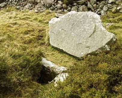
axe factory. ~ 1.2 km NW, on Lugmore Hill (O 059 248), on the other side of the wall behind the trigonometric marker is a fine example of a kist. Four large slabs form an open topped box 1 metre long, 80 cms wide, and at least 70 cms deep (the bottom is filled with rocks). The roof-stone is lying next to the open grave, having been levered off and overturned. The exposed underside is flat, whereas the top is domed. The tomb is probably from the Bronze Age.
~ 4.5 km due West is a cairn and small passage-tomb near the top of Knockananiller Hill (O 019 237). The cairn is 20 metres in diameter and 4 metres high. From the top it is easy to see the remaining orthostats of the tomb poking through the remains of the mound. The passage of the ruined tomb is aligned northeast to the mid-winter solstice sunrise. To the west of the chamber is a circular bank. My colleague Ian Thompson came here on the morning of the 1st August 2004 (Lughnasa) and wrote:
"This morning's sunrise was superb. As the sun peeked above the horizon at 05:39 it seemed to hover above Lugg just as I had thought it would do. I had made a slight miscalculation in its precise location however, and was pleasantly surprised to see it rise right behind Ireland's Eye - the small island to the north of Howth. As the sun rose its reflection in the sea between Dublin and Howth was an impressive sight. Dublin has expanded to the east by at least a mile and 4000 years ago there would have been no land visible between the top of Lugg and Howth. Bearing this in mind, it would have looked as if there were two suns then - the false one appearing as a reflection between Howth and the top of Lugg ... very, very impressive! "After seeing this today I am in no doubt that this
cairn and passage tomb were built here to mark this very special
sunrise. I think it most probable that Lughnasadh festivals
were held at this cairn in the past." Boherboy:
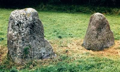
Standing-stones 1.2 km SE of Saggart village centre and about 30 metres S of the road to Tallaght, are two stones 1.2 and 1.3 metres high, only 1.7 metres apart. One is pointed and the other flat-topped: Adam and Eve - though the locals name them the other way round!
Other male-and-female pairs are at Sandville (under Cregg) county Derry, Tulnacross (under Beaghmore), county Tyrone, and Ballymakane (under Buncarrick), county Wexford. ~ 3.2 km S, about 400 metres E of the road to Blessington, 250 metres E of of a farm at the end of a lane, in Raheen (O 038 235), is a massive standing-stone 2.1 metres high, with a line of 5 (artificial ?) hollows about 4 cms in diameter on the top right of its S face.
Bremore:
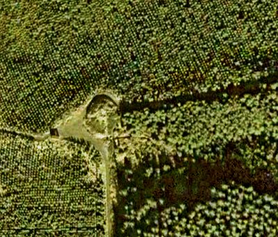
Passage-tombs This
group of tombs is in an amazing location above the seashore.
Of the five mounds the central is the largest at over 3 metres
high and 30 metres across. The other four appear to be satellites.
There may have been more to the north of the main mound at one
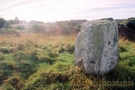
time, but they would have been washed into the sea ~ 4.8 km S in Balrothery (O 202 612) is a small but handsome squarish standing-stone 1.3 metres high - now the centre-piece for a communal green space in a small housing-estate. The photo below (by Ian Thompson) shows the stone just before the houses were built.
~ 5 km
WSW of the Balrothery stone, high above the Delvin River at
Knockbrack (O 155 597), four mounds, probably containing
passage-tombs, mirror those at Fourknocks (county Meath)
on the opposite side. Together, these two important groups make
the Delvin valley a very special place indeed. The mounds seem
to be in two pairs with the best pair being to the S, affording
fine views to the coast near to Bremore and south towards
Lambay. None of the mounds show any signs of kerbs - but neither
did the tombs at Fourknocks. Brenanstown
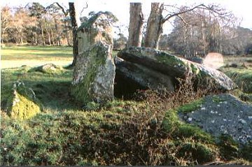
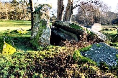
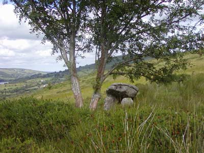
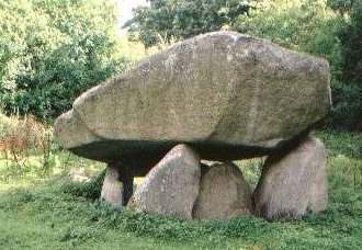
(Glendruid): Portal-tomb Hidden in a small glen
behind a modern bungalow ('Glendruid House') some 800 metres
SSW of Cabinteely and on the left-hand side of the Brenanstown
road when approaching from the N.7 and 400 metres past a signpost
pointing to Tully Church and Crosses, this superb dolmen is
well worth the trouble of finding and asking permission to visit.
Seven granite uprights support a huge, characteristically-tilted
capstone some 4.5 metres square and weighing 40 tonnes. This
is one of the few megalithic tombs to be approached from above,
so that one can see 2 artificial channels forming an inverted
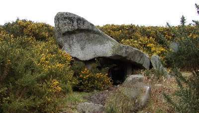
V carved on the top of the roofstone. ~ 2 km SE (O 255 230), surrounded by surburbia, immediately W of the Ballybrack-Bray road and 200 metres N of the junction of it with the Bray-Killiney road, in a football field opposite a house emblazoned with the name "Cromlech", and entered via a door in the hedge, is Ballybrack "Cromlech": a granite portal-tomb. It too has a typically tilted capstone 2 metres long raised 2.7 metres from the ground, with a single deep cupmark. Despite the disappearance of some sidestones and the backstone, the dolmen is worth finding. ~ 4 km WSW in Kiltiernan (O 197 224), 1.5 km SSE of Stepaside, along a cul-de-sac leading off the N.43 for 500 metres, then up a private avenue and across 3 stony fields along a rough path which leads to the megalith from above, is another portal-tomb with a huge, soaring capstone - which has displaced some of its supporting stones - and a very large chamber. "The whole monument has the appearance of a sphinx-like monster, advancing out of the rocky hill on some half dozen short and rickety legs." The Kiltiernan and Ballybrack tombs are linked by the Laughlinstown river. The gorse around the tomb was cleared in Spring 2007.
~ 5.5 km WSW is Ballyedmonduff wedge-tomb. Fourknocks:
Passage-tomb see under county Meath Howth:
Portal-tomb In the grounds of Howth Castle, romantically situated some 230 metres to the right of the entrance to the Rhododendron Walk, this dolmen has partly collapsed under the weight of its huge capstone, estimated to weigh 70 tonnes, which evidently came from the steep quartzite face of Muck Rock above ~ beyond which, right on the tip of the Ben of Howth (O 280 379) is a roofless kist in a significantly-sited cairn whose damaged chamber is some 30 cms deep and 70 cms square. This cairn is visible from very many megaliths in the area - even from as far away as Fourknocks in county Meath - and seems to be a kind of prehistoric nexus. To the west of the Ben there is a small hillock and this, too, has a cairn on its summit. A third one, now flattened almost to ground level, is S of the roofless kist on the Ben. A fourth, northernmost, cairn is sited on a spur above Muck Rock in such a way that the two islands of Ireland's Eye and Lambay Island line up with it to the north. This cairn too is almost levelled but still contains a small kist. Seahan:
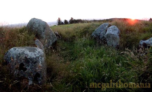
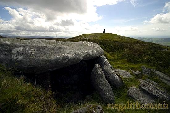
Passage-tombs The most obvious monument
on Seahan Hill is a cairn some 25 metres in diameter and two
metres high, with a trigonometric marker on top. The southernmost monument on the hilltop is a ruined passage tomb. It has an exposed round chamber and a short passage opening to the southwest. A large stone blocks the entrance to the passage.The chamber is just 1.8 metres in diameter, while the passage is no more than a metre long. At the rear of the chamber there is a solid quartz orthostat. 100 metres E is a large passage-tomb with a kerb very well defined on the S side, with enormous stones up to 2 metres long, set on edge. The cairn covering the (central) chamber is so low that the roofstone and part of the chamber and passage are exposed.
Further E again are the remains of a small, roofless and cairnless, outlying, 'undifferentiated' passage-tomb whose passage merges into its chamber. Two parallel rows of upright stones are crossed by a low sill-stone, and then the rows continue while getting farther apart, then close together to form an 'undifferentiated' chamber. Needless to say, the hill offers superb views. I am indebted to Tom FourWinds (www.megalithomania.com)
and his GPS Locater's He
is the author of: an exhaustive, well-illustrated and well-presented
guide and gazetteer to |