county list
![]()
|
Turn smartphone to horizontal
view. SELECTED SITES IN COUNTY TYRONE Place-names in italics refer to listed entries. Convert Irish Grid references to Latitude/Longitude |
|
click
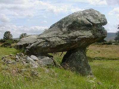
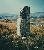
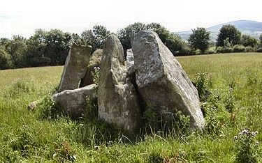
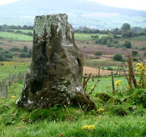
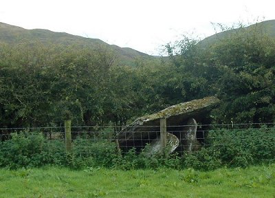
on the thumbnail for a better photo 2.5 km ENE of Greencastle (N of a by-road below a picnic table by a stream) and 800 metres SSW of Dún Ruadh multiple-kist cairn and circle, this is one of the very few Ogam stones in the north of Ireland, and almost certainly a standing-stone before Ogam was cut into it. The stone, 1.2 metres high, has been re-erected. The much-worn inscription has been interpreted as DOTETTO MAQI MAGLANI - of which only seven letters can now be read. About 120 metres to the W is another, handsome (but ogamless) standing-stone about 2.2 metres high. ~ 2 km SE in Formil (H 628 830) is a leaning standing-stone some 1.6 metres high, on a NE slope with views NNW to Dún Ruadh (see below). At H 631 825 in the same townland is another one, rather chunky, 1.4 metres high and 1.3 wide and 1 metre thick. ~ 6.5 km E are Beaghmore stone circles and rows.
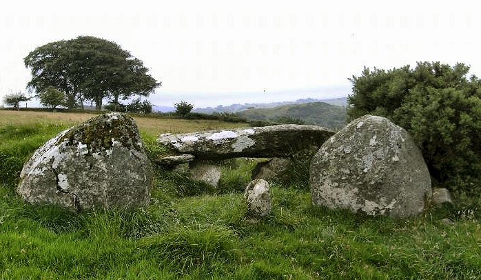
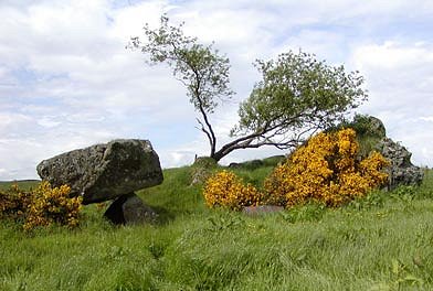
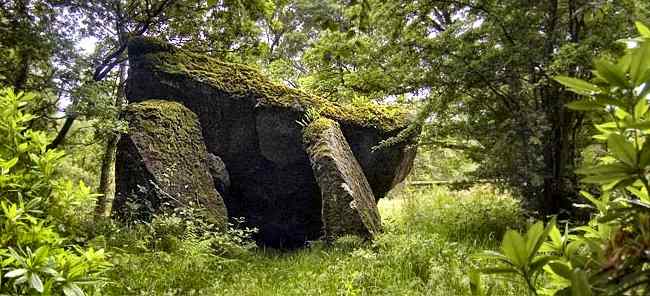
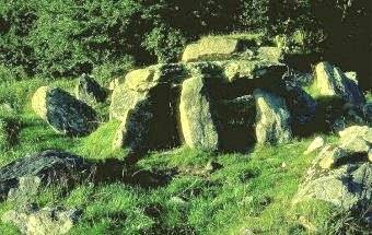
Altdrumman: Portal-tomb Marked
as "Chambered Grave" on the map, this picturesque dolmen resembles
the much larger one at Carrickglass, Sligo, both for the herbage
growing on the massive capstone, and for the relative smallness
of the supporting stones - which are not as tall as the one-metre-thick
capstone. It is known as The Cloghogle (Irish: cloch togálach
= raised stone). ~ 1.2 km NE, to the E of a by-road in Loughmacrory (H 585 776) is a fine wedge-tomb known as Dermot and Grania's Bed, offering fine views. Four of its five roofstones are in place, much of the cairn survives, and the entrance to the antechamber or portico has a dividing-stone similar to that at Dunnamore. A tree now grows picturesquely out of the gallery. ~ 800 metres E by N of the portal-tomb, also in Loughmacrory, immediately SW of a by-road (H 585 770), is a court-tomb, stretching some 25 metres back from the road. Much of the cairn and kerb - and presumably the gallery - survive. At the SW end are the apparent remains of 2 subsidiary chambers.
~ 850 metres N by E of Altdrumman portal-tomb, 140 metres E of Lough Fingrean (marked "Cairn" at H 568 777), is another intact court-tomb (with roofstones); and 130 metres S of this a kist whose large capstone only is visible on top of a low mound. ~ 2.2 km E by N of the Altdrumman tomb is the stone circle complex at Copney. ~ 5.5 km SE, standing in the car park of the church at the north end of Carrickmore (alias Termon Rock) village (H 616 728) is a kist, whose angled capstone rests on three upright stones forming an open-fronted box. It seems to have been moved from the townland of Aghagogan (?)
~ 7.2 km SE of the portal-tomb is another portal-tomb at Athenree (H 629 714, also marked "Chambered Grave"), 300 metres behind (E of) Termon House, approached by a private track from the stableyard. Before one of the portal-stones crumbled away under the weight of the enormous capstone (4.8 x 3.6 metres and 1 metre thick), it must have been quite magnificent.
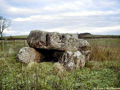
Balix Lower: Single-court tomb 300 metres up a hill from a two-storey farmhouse to the W of a by-road, is a tomb (known as "The White Rocks") with a V-shaped forecourt leading into a (probable) two-chambered gallery which ends in a high-pointed backstone. The N arm of the forecourt leads to an entrance-sill, and the S arm leads to the middle of the S entry-jamb. ~ 1.7 km SSE are Clogherny wedge-tomb and stone circle (H 488 945). ~ Just under 8 km WNW in Knocknahorna is a fairly complete circle of some 50 small stones encompassing an area about 50 metres in diameter, with traces of a stone-lined entrance and two portal-stones 1.2 metres high on the SE side. In the centre is a peaty mound. Ballyrenan:
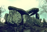
Portal-tombs click
on the thumbnail for larger pictures To the N of a narrow
by-road leading E off the Newtownstewart-Drumquin road is a
long cairn (scattered as is much of Ireland with agricultural
refuse and now (2003) outrageously and almost impenetrably overgrown)
at whose W end is a picturesque and unusual double portal-tomb
(The Cloghogle) roofed with two lintels and two roofstones
- both of which have several cup-marks (or natural solution-pits).
The excavator thought that a subsidiary tomb had been built
against a primary one. At the E end of the cairn is another
portal-tomb, roofless, with a high sill-stone and tall portal-stones.
Near the W end of the cairn is a small rectangular block of
stone with criss-cross grooves on its upper horizontal surface.
~ 6.4 km NE is another portal-tomb at Crosh (H 417 879), whose capstone has fallen from the portal-stones which are over 3 metres high, and between which is a door-slab 1.2 metres high.
~ Just 500 metres W of Crosh (in Glenknock, H 412 879) is a completely collapsed portal-tomb.
~ Just under 2 km N by NE of Crosh in an undetermined townland (H 419 897, marked on the map) is a large and chunky standing stone with a flat top and several knobs and fissures.
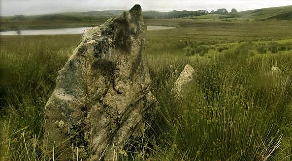
~ 3.8 km SSW is the court-tomb at Legland (see below). ~ 6 km WNW of Ballyrenan on a hillock on the N side of the River Derg in Crew Lower (H 315 848) is a pair of standing-stones 1.8 metres apart and slightly less in height. Other standing stones in the area include one of a cluster in Killeen (H 332 869) 2.1 metres high, another one not quite so high at H 324 873, and a pointed one 2.3 metres high, incorporated into a field-wall at Magheracoltan (H 363 866). ~ 6.2 km NNW of Ballyrenan and 1.5 km NNW of Ardstraw, beside a farm in Clady Halliday (H 344 886) is a single-court tomb with 3 chambers, a large, horseshoe-shaped forecourt, and some dry-walling between the low orthostats of the court. Some corbel-stones to support the roof remain on the much larger first chamber. Ballywholan
(pronounced 'Ballyhollan'): Double-court
tomb and portal-tomb Approached by a signed and fenced walkway 200 metres NE of the Greaghnasunna Bridge over the Fury river, 5.6 km SE of Clogher, visible from the Corleaghan Road, stands "Carnagat" (the cat's cairn) - a small, relatively well-preserved tomb with much of its cairn. It is about 20 metres long, and composed of two double-chambered galleries and forecourts. A frontal kerb joins the SE court to the sides of the cairn. The NE court has tall flanking-stones, and one of the jamb-stones bears a cup-mark. Matching stones on either side have large L-shaped notches. The backstone of the N gallery is gabled. Roof-slabs are scattered about. At the end of thr 19th century a local farmer took one of the lintel-stones to build a barn, but when it was cemented in it emitted a strange radiance. The farmer returned it to the tomb - whence it subsequently disappeared, presumably incorporated in another local building by a less-sensitive man. ~ 2.4 km NE and 120 metres N of another by-road in the same townland is "Carnfadrig" or "Carn Patrick", another cairn over 20 metres long, surviving to a height of over 2 metres. At the E end are remains of a portal-tomb with a rectangular chamber composed of 3 long slabs and a three-quarter sill which has fallen into the chamber. One portal-stone has fallen against the other. At the W end of the cairn is a long subsidiary chamber or gallery divided into two or possibly three sections, but no entrance to it is now apparent. This complex monument shows very well the relation between court- and portal-tombs.
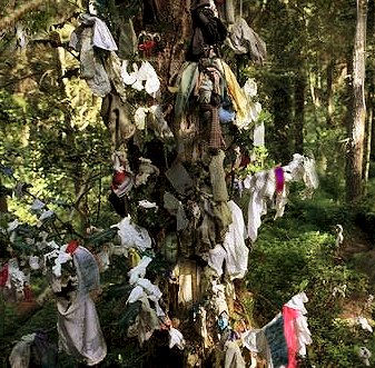
~ 3 km NW of Carnagat on an eminence in Ballyscally and affording good views (H 544 483) is a standing-stone just 1.1 metre high. ~ 1.4 km NNE of Carnagat, on a ridge S and W of the Dunroe Road in Derrydrummond (H 573 485) is another court-tomb, somewhat obscured by field-walls. The court is at the S end with another stone a short distance to the S, and two chambers can clearly be discerned. A possible subsidiary chamber opens from the W end of the cairn, which is only 9 metres long. The tomb was excavated in 1899, and urns, cremated bones, ashes, 5 burial pits and one flint tool were found. ~ 2.4 km ESE of Carnfadrig and 1.7 km NE of Carnagat, in Cullamore, near the top of Cullamore Hill about 400 metres NE of a by-road, is "The Giant's Grave" - another court-tomb, smaller and somewhat ruined, but with some fine court-stones. One has fallen to reveal dry-stone filling. At present only 2 chambers (with good jamb-stones) survive intact. ~ 2 km NE of Cullamore, at Altadaven in Favor Royal Forest (H 596 496) is "St Patrick's Chair and Well". Perhaps no place in Ireland seems closer to the dark Celtic Otherworld than "Spink-ana-gaev" (splinnc means cliff, crag or pointed rock in Irish), a strange and eerie pile of boulders. "St Patrick's Chair" is a massive block about 2 metres high, shaped like a chair and probably at least partly-artificial, sitting on a another large block amongst a dozen or more other blocks, one of which has a cup-mark and an unfinished cup-mark. Below the Chair is the well - in fact an open chamber above which is another massive boulder containing a fine bullaun 25 cms in diameter. It is said "never to run dry" - this is not surprising as the fern-covered site is like a miniature rain forest: every rock drips with water. A supporting boulder has a good cup-mark. Between the bullaun and the chair above are two Rag Trees, where some 'offerings' remain.
Altadaven
means "The Demons' Cliff", over which St Patrick (or St Brigid)
is reputed to have driven devils - thus pointing to the site's
ancient ritual significance. Lughnasa (Lammastide) celebrations
were held here until relatively recently. The well is also known
as "St Brigid's" and the confusion between the two saints (the
latter bearing the same name as the virgin aspect of the triple
moon-goddess) suggests that the site was hardly - if ever -
Christianised. Beaghmore:
Stone circles and rows click
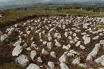
on the thumbnail for larger pictures Some 13 km WNW of Cookstown, to the W of a by-road, this superb site is the only maintained, excavated stone-circle site amongst nearly 150 in the Sperrin hills. Circles of small stones with tangential alignments of larger ones are common in the central Tyrone and E Fermanagh area, and at Beaghmore a group of these, together with about a dozen small cairns were uncovered during peat-cutting. More lie in the uncut peat-bog beyond. At present 7 circles and 9 rows can be seen - the stones of the rows being from a few centimetres to 1.8 metres high. Burials and kists were found in some of the cairns. One stone circle is filled with hundreds of small stones set upright. The find of a Neolithic bowl suggests that Neolithic occupation and cultivation preeded the erection of burial cairns and ceremonial circles and alignments: some irregular lines and heaps of boulders resembling field-fences or field-clearance may predate the ritual structures. At some stage peat started to form over the site, and it may conceivably be that the cairns and rows were erected in a futile propitiatory attempt to restore fertility to the soil by attracting back the fading sun - for the significant alignment is not astronomical, but, as with wedge-tombs, towards the setting sun and the Land of the Dead. ~ Just over 3 km W
by N at Broughderg (H 654 843) on the E side of the road
just N of a junction, in a rough, rushy field, are two contiguous
stone circles with a small cairn and a standing stone, 1.5 metres
high, set between them at the NW. The N circle is comprised
of ten stones and the S has 14 stones remaining. ~ 3.2 km S is Dunnamore wedge-tomb. ~ 6 km W is Dún Ruadh multiple-kist cairn. ~ 4.2 km SE in Tulnacross,
in a field to the N of the road from Orritor to Dunnamore (H
705 804 - not marked on the map), is a pair of standing-stones.
From a distance one appears to be pointed (male) and the other
flat and grooved (female), but on approaching closer the 'male'
one has a groove in it and the flat one turns out to be pointed
- a prehistoric monument to sexual ambivalence, perhaps! Compare
other pairs at Boherboy, county Dublin, Ballymakane
under Buncarrick, county Wexford and Sandville
under Cregg, county Derry. But in another direction entirely there is a shapely stone 2.15 metres high at Tattykeel (H 748 774), 5.3 km ESE of the Tulnacross stones and 7.2 km ESE of Dunnamore wedge-tomb, just E of a farm track. ~ 3 km NNE of Beaghmore in Davagh forest are Davagh Lower double stone circle, alignment of three stones, part of another stone circle, and (600 metres SW) a low wedge-tomb whose roofstones are still in place. ~10.5 km N by W in Goles, a short distance N of the B47 Draperstown to Plumbridge road along the Glenelly valley (H 669 948 - protected by fencing but not marked on the map), a fine alignment of 9 stones ranging from 0.2 to 2.0 metres high, runs uphill for 15 metres. Castlemervyn:
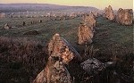
Stone circle This picturesque ruin, by a tree in the hollow of a field, was originally some 12 metres in diameter, and had perhaps 6 large stones, the tallest of which (now overturned) was nearly 2 metres high. ~ 5 km SE in various townlands on Brougher Mountain in county Fermanagh are various standing-stones and other megalithic remains. Clogherny
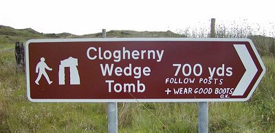
: Stone circle and Wedge-tomb click
on the thumbnail for larger pictures Below and N of Meenerrigal Rocks, some three hundred metres up a slope to the E of the Plumbridge-Dunnamanagh (Donemana) road, a wedge-tomb with a straight façade, a fine sill-stone and one surviving roofstone is set in a round cairn which is surrounded by a circle (18 metres in diameter) of low stones mostly about 90 cms high. The monument (marked 'Chambered Grave' on the map) enshrines the various building-practices of the court-tomb, wedge-tomb and stone circle cultic traditions. The tallest of the stones (about 1.5 metres high) is just visible on the skyline across the moorland to the W of the picturesque Butterlope road, from where the monument is now signposted, with a path.
~ 1.7 km NNW is the court-tomb at Balix Lower. ~ 6.2 km SE in Glenroan (H 547 914) is 'Dermot and Grania's Bed', a half-collapsed and lurching portal-tomb trapped between barbed-wire and a thicket, whose thin roofstone is just over two metres square and rests on one portal-stone (1.3 metres high) and two sidestones. There was once a small, second capstone bridging the gap between the large roofstone and the backstone. A 'half-door' or high sill-stone stands 80 cms high between the portals. This tomb is, amazingly, signposted - whereas the fine monument at Ballyrenan (above) languishes unmarked and overgrown. Copney:
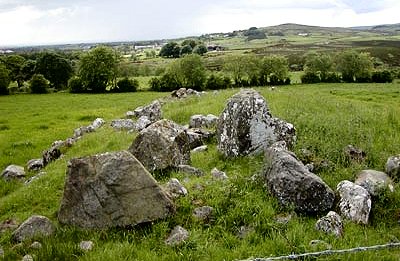
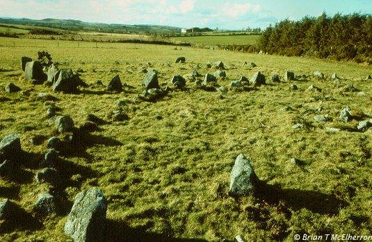
Stone circles, alignment and cairn click
on the thumbnail for a larger image On the slopes of Copney Hill are eight complete or partial stone circles (only recently been dug out of the peat), each filled with set stones (in some cases concentrically) and some with a central small cairn. There is also an alignment of low stones running down the hill. To the NW (at H 597 783) is a cairn some 3 metres in diameter and 1 metre high with a large capstone still in place, and 100 metres further E is an arc of eight low stones. This is part of a particular megalithic landscape within the large megalithic landscape (or vast prehistoric theatre-set) that fills the area immediately S of the Sperrin Mountains. ~ Further to the W are the megaliths of Loughmacrory and Altdrumman. Cregganconroe:
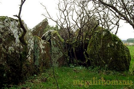
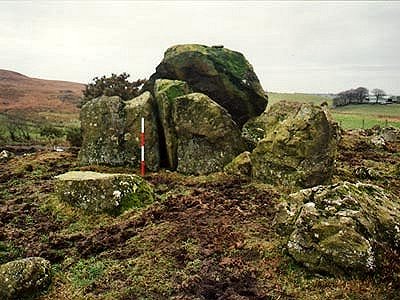
Court-tomb This impressive tomb has massive portal-stones but few other stones of its shallow forecourt surviving. It leads into a two-chambered gallery, past a large fallen lintel. Behind the gallery are two lateral chambers opening symmetrically into each of the long sides of the cairn, which is 25 metres long and includes large boulders. Though roofless, these subsidiary chambers resemble small portal-tombs.
~ In the same townland
and close to a by-road (H 650 752) is a typical Mid-Ulster circle
complex, situated on the top of a round platform between two
lakes The tall stones that are visible are actually a tangential
stone row that runs E-W, with the tallest stone (1.4 metres)
at the west. At the east end of this row and to its north are
six stones of the stone circle, just 50 cms high. More stones
may be buried in the bog.
~ 1.8
km E at Murnells (H 680 757) is a fine but almost unknown
portal-tomb (Dermot and Grania's Bed), whose large capstone
has been swung to one side to create a dramatic overhang. The
rear of the main capstone rests on a secondary capstone, which
in turn rests on a small chocking stone. This actually gives
the impression that it has three capstones. The larger capstone
has a deep natural cupmark at its apex. A short distance to
the E is a round cairn measuring 16 metres in diameter and 1.5
metres in height, composed of rough stones with large stones
near the centre: possibly part of a kist or kists. ~ 5.6 km N by E is Dunnamore wedge-tomb.
Dunnamore:
Wedge-tomb Best approached via
a lane (and across 2 fields to the E) leading from the road
at the derelict police barracks, which are a few hundred metres
W of a modern school in Dunnamore, this "Dermot and Grania's
Bed" is impressive - despite a cart-track driven between
the large stones of the double wall of the gallery and what
seem to be the stones of the kerb (12 metres long). The gallery
is about 8 metres long, and the main chamber is still roofed
with 3 large slabs. At the front of the tomb (facing SW) is
an antechamber or portico which retains a roofstone and has
a stone set between the entrance stones to form a double jamb
- a feature of some other wedge-tombs in Tyrone. At either side
of the dividing-stone are low sills. Some small chocking-stones
also support the roofstone. A curious feature of the monument
is a short line of stones running NW from the NW side of the
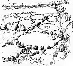
gallery towards an enormous boulder. ~ 7.2 km SSW is Creggandevesky court-tomb (H 644 752) on a hill overlooking Lough Mallon. This tomb, which has an impressive entrance with massive lintel, is built at the head of a valley extending westward with excellent views (on a good day). A trapezoid cairn contains a three-chambered gallery with a court at the SE end. The edges of the cairn (18 metres long) are clearly defined by a dry-stone revetment along the E and W sides. Excavation showed that the back of the tomb was partially robbed in prehistoric times, and that it was built before the middle of the fourth millennium BCE. In the same townland (H 6260 7219) was a sweathouse, whose roof recently collapsed, 100 metres S of which (down the slope) was a stone-lined plunge-pool used, according to local information, for mud baths. At H 6422 7529, on a slight rise in a field, is a probable wedge-tomb with a probable roofstone on top of a cairn some 9 metres long, 5.5 metres wide and just over one metre high. Until the 20th century there were many stone monuments in this townland. ~ 5.6 km S by W is another court-tomb at Cregganconroe. ~ 7 km SSE at Moymore (H 711 745) is a group of 9 circles together, one of which has a ten-stone row almost 15 metres long. Unfortunately, the grass around the mainly-low stones is too high to get a proper idea of the lay-out. What can be seen very well are two rows of stones at right angles, which stand around one metre tall. Not until you walk through the site will the visitor start to notice most of the hidden stones. What a site this would be if it were cleared ! The longer of the two clearly-visible rows is around 10 metres, and the shorter about 5. On further inspection two other broken rows of similar scale can be seen which (together with the clearly-visible rows) would form a large rectangle. If so, this would be the only megalithic rectangle in Ireland, if not the British Isles!
Unlike Beaghmore, the circles here are compressed into a small, fenced in area measuring roughly 50 x 20 metres. A large pile of rocks in one corner suggests that the complex once contained a lot more and covered a larger area. There are also two large stones set into one field boundary, so there may have been some more of the large rows in the next field, too.
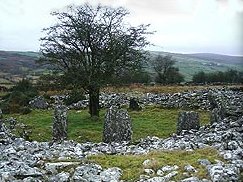
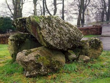
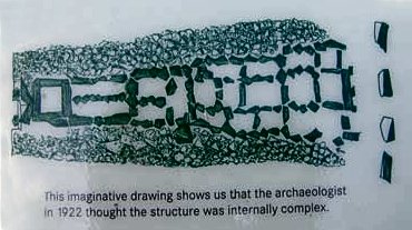
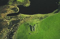
Dún
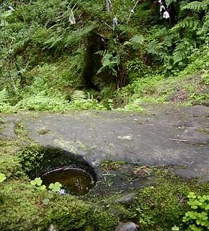
Ruadh: Multiple-kist cairn and henge 3 km NE of Greencastle and 800 metres NNE of Aghascrebagh ogam stone, over fields behind a farm in Crouck townland, to the E of a by-road and 450 metres E of the old school, this monument (whose name means "The Red Citadel", was much plundered to build the school. But the site remains impressive, comprising an oval kerbless cairn about 30 metres long, surrounded by a ditch and a low earthen bank. The cairn was built around an open cobbled area, lined by 17 orthostats in a circle, which were linked by dry-walling. There is a paved entrance on the SW. Thirteen kists were said to have been in the secondary surrounding cairn, some of them well-constructed, others merely improvised among the boulders of the cairn. A tree now grow in the central area. The Bronze Age monument is decidedly 'anomalous' and has affinities with both the passage-tomb at Sess Kilgreen and with the closed ring-cairns of NE Scotland. ~ There are remnants of a gallery-tomb in the adjacent field to the SW, and about 400 metres N by E, in Carnanransy, immediately S of the Greencastle-Draperstown road, are remains of a smll court-tomb with a semicircular court of 5 orthostats. ~ 2.8 km NE in Keerin (H 643 865) is a neat little portal-tomb almost completely buried in bog. The capstone is just 90 cm wide and a little over 1.5 metres long, set on two tiny pointed portal stones. Due to being in a peat bog the tiny chamber, which has been dug out, is filled with brown water which does not permit the visitor to determine whether or not there is a door-stone.
~ About 1.6 km SSE is the standing-stone at Formil (see under Aghascrebagh, above). ~ 9.6 km W by N of Dún Ruadh, immediately W of a by-road in Glenmacoffer (H 529 863) are two surviving stones of a stone-row which until recently had three. They are fine slabs about 1.8 metres high and up to 1.5 metres wide. ~ 6 km E are Beaghmore circles and stone-rows. Knockmany:
Passage-tomb At the top of a hill
in Knockmany Forest, approached by a track leading from a car-park,
this tomb has unfortunately been enclosed in concrete to protect
the decorated stones from name-carvers and other vandals. Formerly
known as "Annia's Cove" (corruption of Grania's
Cave), it is open to visitors at certain times in the summer,
and it may still be possible to obtain a key from Clogher police
station. Three of the stones of this almost passageless tomb
are covered with spirals, cup-marks, serpentines, concentric
circles, etc. ~ 6.5 km ENE is another decorated passage-tomb at Sess Kilgreen. ~ 2.2 km SSE on a plinth in a farmyard in Carr (H 553 540) is a handsome standing-stone some 1.8 metres high, tapering to a point. The stone has not been moved, but the ground-level was lowered when the farmyard was created. ~ 5.2 km SW of Knockmany on a hilltop in Findermore (H 518 512) is the "Abbey Stone" a standing-stone 1.7 metres high whose smoothed S face has been Christianised with a Latin cross in false relief. Legend has it that St Patrick preached here for three days and nights. ~ 9.2 km WNW in Ballyness, just S of the road (H 459 531) is a standing-stone, tapering to 2.2 metres high. Legland:
Court-tomb Although something
of a jumble of stones amongst gnarled hawthorn trees, this tomb,
on a SW spur of the hill called Bessy Bell is interesting because
it was excavated in 1940. Right up to the beginning of the 20th
century it was covered by a round cairn some 17 metres in diameter
and 7 metres high. The shallow court is at the NE end and is
a little difficult to distinguish because it is littered with
large irregular boulders. Three court stones on the south side
of the entrance (one of which has a layer of quartz on its inner
face) are matched by three stones in the northern arm of the
court. Between two of these there appears to be some dry-stone
walling intact. Stretching between the ends of the court arms
is a row of low sill-like stones forming a low wall across the
front of the court. The entrance-jambs are unusual in that one
is aligned with the court and the other is aligned with the
gallery.
~3.8 km NNE are the two portal-tombs at Ballyrenan (see above). ~ 2.6 km ENE at Glassmullagh
(H 387 804) are very low stone circles and alignments reminiscent
of Beaghmore, but only some of the stones are barely protruding
from the moor. Two circles out of 4 reported and and two rows
can be distinguished. The site offers extensive views to the
S. ~ 8 km WNW in Carncorran Glebe (H 288 824) are the remains of a portal-tomb: just two massive and mis-matched portal-stones nearly 3 metres high, with a tiny door-stone in between.
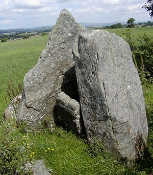
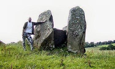
Leitrim:
Portal-tomb In a field-fence to
the E of a by-road, this megalith is remarkable for its large
capstone (over 3 metres square) which contains nodules of gleaming
white quartz.
It is characteristically tilted to a height of 2.75 metres on
portal-stones just 1 metre high. On top of the capstone are
several depressions, some of which may be artificial. ~ 5.6 km NE at Berrysfort (H 272 838, 1.5 km SE of Castlederg), approached by farm lanes and across a field is a handsome standing-stone 2.3 metres high, standing on a small eminence just S of the river Derg. ~ 6.5
km NE in Churchtown (1 km N by E of Castlederg at an
altitude of 100 metres) is "Todd's Den", a small
megalithic cairn about 10 metres long by 3 metres wide. In
it are remains of several chambers with capstones which have
been slid to one side - presumably by fox-hunters, for Tod
is English dialect for Fox. At the S end of the cairn
is a standing-stone which might have been a portal. ~ 8.5 km SSW in Ally is a court-tomb described under Drumskinny stone circle in county Fermanagh. Loughash:
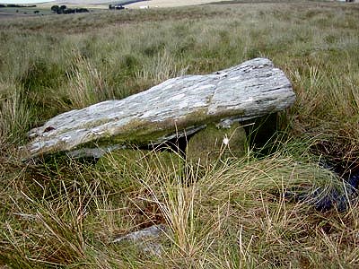
Wedge-tombs and stone circle Immediately N of a by-road 6.5 km SSW of Claudy, this complex monument (known locally as "Cashelbane" - The White Fort) overlaps the design or cult of court-tombs with that of wedge-tombs in having a vestigial semicircular forecourt facing south, and in being divided into 5 chambers, over which a single roofstone remains. These comprise an antechamber/portico with a double portal, a main chamber divided into two by 'skeleton jambs', and two compartments or kists separated from the main chamber by high orthostats. The double-walling is here linked to the gallery by transverse slabs. The roughly-circular cairn was surrounded by a ditch, suggesting that an older structure was destroyed. A small stone circle with tangential alignment lies less than 200 metres SE of the tomb. ~ 3.2 km W by S, in the same townland is "The Giant's Grave", another wedge-tomb with segmented chamber. The west-facing entrance is made double by an orthostat which bears 12 small cup-marks on its N side. ~ Almost 9 km NW is Cregg standing-stone, county Derry. ~ Some 13 km E by N is Tireighter wedge-tomb, county Derry. Loughry:
Wedge-tomb A short distance south of Cookstown, in the grounds of an Agricultural College, this wedge-tomb seems to be formed mainly of large limestone boulders, and sits on the summit of a glacial knoll. Only the larger structural stones remain, so that it looks rather like one of the thousands of limestone-built tombs on the French causses. There is no trace of the original cairn. A rectangular gallery 7.6 metres long by 1.5 metres wide is formed by eleven sidestones, with a single backstone at the E end. There are two large roofing lintels in place, resting on the first two pairs of matching sidestones. There are three stones of an outer wall along the N side and one stone at the S side. Three stones at the W end seem to form a façade.
~ 6.5
km WNW is the standing-stone at Tattykeel (see under
Beaghmore, above). Sess Kilgreen: Passage-tomb H 60403 58432 Sheet 19 click
on the thumbnail for high-resolution pictures Approached through a farm to the S of the Ballygawley-Omagh road a few hundred metres before Sess Kilgreen school, this monument is surrounded by bushes. Wellington boots are essential. Like Knockmany, 6.5 km WSW, this tomb is roofless and has no passage. Worn decoration can be seen on 2 of its stones, in the form of lozenges and superimposed concentric circles similar to some on a rock outcrop in the Canary Islands, and others in the Boyne Valley and Brittany. In the next field (H 603 585) is a single slab 1.5 metres high - used by cattle as a rubbing-post - which is said to have been the (re-used ?) capstone of a chamber containing bones and 2 pots. It is covered with cup-marks, spirals, concentric circles, and flower-like motifs, and is divided diagonally by a row of cup-marks. |
 sketch by Ann Johnston